Librarian

Contact Us
Maps for Oklahoma History
We have found these maps to be very useful classroom settings. Below each map you will see two different download links. The first, called Download normal size, is appropriate for most uses, including printing on an 8.5 x 11 sheet of paper. The second download, called Download large size, should be used if you plan to print a poster sized version of the map.
After clicking on the download link, you'll be taken to a preview page (some are too big to preview, don't worry!). To complete the download, click the  icon in the upper right corner of the screen.
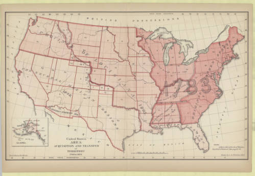
United States Area: Acquisition and Transfer of Territory, 1780 to 1870 (1872)
Shows the territorial expansion of the United States over time.
Download normal size (recommended for most uses)
Download large size (recommended for poster printing)
More information about this map
Indian Territory (1889)
Shows the locations of tribes removed to Indian Territory and also shows that the panhandle is not yet attached.

Download normal size (recommended for most uses)
Download large size (recommended for poster printing)
More information about this map
Oklahoma Territory (1907)
Shows how Oklahoma Territory would look as a state separate from Indian Territory.

Download normal size (recommended for most uses)
Download large size (recommended for poster printing)
More information about this map
State of Sequoyah (1905)
Shows the proposed state for Indian Territory, complete with county shapes and names.

Download normal size (recommended for most uses)